Alongside the popular Great Walks, New Zealand’s many short walks and day hikes offer endless opportunities for families with older kids and teens to explore the great outdoors. Here are 19 of the BEST short walks and day hikes for families looking for shorter, more accessible experiences.
The walks are spread through both the North and South Island, and many are close to towns and cities or popular tourism destinations. The walks are graded for adults and teens and range from the ‘easy’ 45-minute Lake Gunn loop (accessed off the Te Anau – Milford Road) to the ‘advanced’ 7.5km / 6-hour Te Whara Track on the coast near Whangarei, north of Auckland.
Tracks were chosen for their beauty and variety of environments, as well as accessibility and good visitor facilities.
Short walks (30 minutes – 3 hours) will appeal to those with less time and itineraries and allows families to experience parts of New Zealand’s varied natural heritage. Day hikes (4 – 6 hours) are suited when you are visiting the region longer than a day but don’t want to have to commit to a multi-day trail experience with the kids.
Short walks (30 minutes to 3 hours)
MOUNT MANAIA TRACK, WHANGAREI
GRADE: EASY
At Taurikura Bay, east of Whangarei, take an easy 3-hour wander (3.5km) through regenerating native forest to the summit of Mount Manaia (403m above sea level), where rocky outcrops create perfect natural lookouts for spectacular views across one of New Zealand’s most dramatic harbour entrances. Other highlights include impressive forests of large tree ferns (punga), views of Bream Head and the Hen and Chicken Islands.
Getting there: Whangarei is just over two hours by road north of Auckland. Mt Manaia is 30 minutes east of Whangarei on Taurikura Bay.
More information and detailed maps: Mount Manaia Track
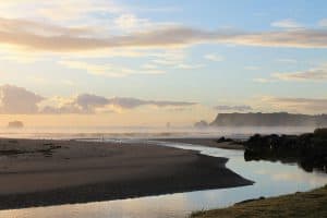
MANGAWHAI CLIFF WALKWAY, WHANGAREI
GRADE: EASY
Journey from beaches to cliff tops, through farmland and native forest on this easy 3-hour / 5km coastal walk to discover views of Bream Head, offshore islands and the Hauraki Gulf. Highlights include the ‘giant staircase’ – a natural rock amphitheatre, clifftop ocean views to offshore islands, native nikau, pohutukawa and taraire trees clinging to the almost sheer slopes below.
Getting there: Whangarei is north of Auckland and just over two hours by road. On the Twin Coast Highway, the walk starts an hour from Whangarei.
More information and detailed maps: Mangawhai Cliff Walkway
RANGITOTO SUMMIT TRACK, AUCKLAND
GRADE: EASY
Iconic Rangitoto Island dominates the sea views from Auckland city out into the Hauraki Gulf. It is the youngest and largest of Auckland’s many volcanic cones. Conquer this dormant volcano with a 2-hour / 4.6km return hike that climbs 256m across scoria slopes to the crater. Highlights include lava caves, views into the crater, the world’s largest pohutukawa forest, panoramic views back to Auckland and beautiful swimming spots.
Getting there: Regular 25-minute ferries leave daily from downtown Auckland for Rangitoto.
More information and detailed maps: Rangitoto Summit Track
CATHEDRAL COVE WALK, THE COROMANDEL
GRADE: EASY
Explore the beautiful Coromandel coastline and its lovely beaches as you walk via Gemstone and Stingray Bays to the famous Cathedral Cove. Highlights include Cathedral Cove’s majestic natural rock arches and caves. This easy 1.5-hour return / 2.5km track follows a well-graded path from Hahei.
Getting there: Whitianga, on The Coromandel coast, is 2.5 hours by car southeast of Auckland. The track starts 50 minutes from Whitianga. Note: A section of Charming Creek Walkway is currently closed.
More information and detailed maps: Cathedral Cove Walk
WAINUI FALLS, GOLDEN BAY
GRADE: EASY
On beautiful Golden Bay, at the northwestern end of the South Island, this 1.5 hour / 3.4km easy walk through native bush and across a swing bridge ends at the thundering Wainui Falls. Highlights include a native forest of nikau palms, rata trees and ferns, and watch out for New Zealand’s giant native snail, Powelliphanta.
Getting there: Golden Bay is 2.5 hours by road from Nelson.
More information and detailed maps: Wainui Falls Track
CHARMING CREEK WALKING TRAIL, WEST COAST
GRADE: EASY
Hike (or mountain bike) along an abandoned railway line that once hauled timber and coal. This easy 3-hour trail travels 9km through tunnels, over bridges and along deep forested gorges. Highlights include spectacular Mangatini Falls, the Ngakawau River and, if you should spot any, rare native snails and the large, daisy-like flowers of clemisia morganii.
Getting there: Westport is about four hours by car from Nelson. The track starts from SH67, about 30 minutes by car from Westport.
More information and detailed maps: Charming Creek Walkway
CAPE FOULWIND WALKWAY, WEST COAST
GRADE: EASY
There are two sections on this easy 1.5-hour / 3.4km (one-way) walk, one to Tauranga Bay, the other to Cape Foulwind lighthouse. With a NZ fur seal colony, a lighthouse and panoramic coastal and mountain views, the Cape Foulwind Walkway is a great walk suitable for all the family. November to January is the best time to view the seals.
Getting there: Westport is 1.5 hours by car from Greymouth, and the track starts 15 minutes from Westport.
More information and detailed maps: Cape Foulwind Walkway
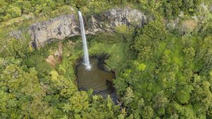
DEVIL’S PUNCHBOWL WALKING TRACK, ARTHUR’S PASS
GRADE: EASY
In Arthur’s Pass National Park, in the Southern Alps west of Christchurch, take a short 30-minute / 1km return walk through beautiful native forest to stand at the base of the spectacular 131m Devil’s Punchbowl Falls. Although the top of the Devil’s Punchbowl Falls can be seen from the main road, the walk to the base of the waterfall is well worth the trip at any time of year.
Getting there: Arthur’s Pass Village is 2-hours by car from Christchurch, or take the TranzAlpine train for a spectacular 2.5 hour rail journey from Christchurch.
More information and detailed maps: Devil’s Punchbowl Walking Track
KURA TAWHITI ACCESS TRACK, CHRISTCHURCH
GRADE: EASY
Explore the spectacular Kura Tawhiti limestone formations on this easy 20-minute / 1.4km return walk. The rock formations can be seen from the highway, but their size is best appreciated up close. See climbers pitting themselves against this world-renowned rock-climbing site.
Getting there: Castle Hill Village is 1 hr 20 mins by car west from Christchurch.
More information and detailed maps: Kura Tawhiti Access Track
LAKE MATHESON WALK, WEST COAST
GRADE: EASIEST
Near the West Coast glaciers of Franz Josef and Fox, wander through an ancient forest and gaze on mirror-like reflections of New Zealand’s highest mountain Aoraki/Mount Cook. This easy 1.5-hour / 2.6km hike around the edge of Lake Matheson follows the track over a suspension bridge, through lush native forest to the jetty viewpoint for magnificent mountain reflections. Dawn and dusk are the best viewing times as the lake is generally calm. The complete lake circuit takes 1.5 hours.
Getting there: Franz Josef is 2.5-hours by road from Greymouth. Lake Matheson is 30 minutes from Franz Josef, beyond Fox Glacier township.
More information and detailed maps: Lake Matheson Walk
FOX GLACIER TE MOEKA O TUAWE VALLEY WALK, WEST COAST
GRADE: EASIEST
This easy one-hour / 2.6km walk takes you past ancient moraines, over small creeks and glacier-moulded landscapes to within 500 metres of the terminal face of Fox Glacier and a short climb to the viewing area. For the first 100 metres of the track you will pass large mounds of moraine that cover ‘dead ice’ left behind when the glacier retreated in the 1960s. The glacier is a beautiful yet volatile place so take care and stay behind safety barriers. It is sometimes closed due to adverse conditions.
Getting there: Fox Glacier is 3.5-hours by road from Wanaka. The glacier walk is just south of Fox Glacier township, turn left before Fox River bridge.
More information and detailed maps: Fox Glacier Te Moeka o Tuawe Valley Walk
BLUE LAKES AND TASMAN GLACIER VIEW WALK, AORAKI MT COOK
GRADE: EASY
In Aoraki Mt Cook National Park, discover the Tasman Glacier – New Zealand’s longest at 27km long – with this easy 1-hour return walk that takes in the alpine-fed Blue Lakes and glacier-moulded landscapes. The path meanders up past the Blue Lakes to a viewpoint on the moraine wall. From there, you can see across the valley taking in the glacier, terminal lake and surrounding mountains.
Getting there: Aoraki/Mount Cook Village is four hours by road south west of Christchurch, and 2.5 hours north from Wanaka. The track is 13 minutes from the village.
More information and detailed maps: Blue Lakes and Tasman Glacier walks
BLUE POOLS TRACK, WEST COAST
GRADE: EASIEST
Roam through beautiful native forests and over a swing bridge to experience the pristine waters and pure azure colours of the Blue Pools. This easy one-hour / 1.5km stroll through beech forest to a swing bridge over the Makarora River and a boardwalk to a viewing platform over the Blue Pools and views up the river gorge.
Getting there: Wanaka is 1.5 hours by road north of Queenstown. The Blue Pools Track is a 1-hour drive from Wanaka, 8km from Makarora on the Haast Highway (SH6).
More information and detailed maps: Blue Pools Track
LAKE GUNN NATURE WALK, FIORDLAND
GRADE: EASIEST
This easy 45-minute loop (accessible to wheelchairs and strollers) is on the edge of tranquil Lake Gunn, in Fiordland National Park. Highlights include picturesque red beech forests and local birdlife, and there are side trips to beaches and sheltered fishing spots.
Getting there: Lake Gunn is one hour / 78km by car from Te Anau on the road to Milford Sound.
More information and detailed maps: Lake Gunn Nature Walk
Day walks (4-6 hours)
TE WHARA TRACK – BREAM HEAD, WHANGAREI
GRADE: ADVANCED
Follow an ancient Maori trail through some of the North Island’s best coastal forests on this 7.5km (5 – 6-hour one-way) advanced hike. Highlights include forests, panoramic coastal views and WWII radar station ruins. You can walk this trail in both directions.
Getting there: Whangarei is just over two hours by road north of Auckland. The track starts from Ocean Rd carpark which is 36 km / about 40 minutes by road from Whangarei.
More information and detailed maps: Te Whara Track
TONGARIRO ALPINE CROSSING, CENTRAL NORTH ISLAND
GRADE: ADVANCED
The active volcanic landscapes of the central North Island are the setting for New Zealand’s best known one-day hike. In good conditions, fit walkers will cover the 19km trail across volcanic craters and ancient lava flows in around eight hours. Highlights on this unforgettable walking journey include the brilliant emerald coloured lakes, steam vents and sweeping panoramic views.
Getting there: The beginning of the Tongariro Alpine Crossing is 1 hour 20 mins by road south of Taupo, and the nearest town is Turangi (40 mins). The Department of Conservation recommends that visitors access the track via a shuttle from Whakapapa, National Park Village, Turangi, Taupo or Ohakune. Several local transport operators offer shuttle services.
More information and detailed maps: Tongariro Alpine Crossing
HOOKER VALLEY TRACK, AORAKI/MT COOK NATIONAL PARK
GRADE: EASY
Discover the lower reaches of Aoraki/Mt Cook – New Zealand’s highest mountain – on this easy 10km or 3-hour return walk. Highlights include the Tasman Glacier Lake filled with picturesque icebergs, the glacier terminal, three swing bridges and, on a clear day, amazing views of Aoraki/Mount Cook.
Getting there: Aoraki Mount Cook rises from the head of Lake Pukaki, and the track is just beyond Mount Cook Village. The national park is four hours by road south west of Christchurch, and 2.5 hours from Wanaka.
More information and detailed maps: Hooker Valley Track
ROY’S PEAK TRACK, WANAKA
GRADE: EASY
Discover the spectacular Wanaka region on this easy 6-hour / 16km / 1300m climb through wild tussock grasslands to the summit of Roy’s Peak. Highlights include sweeping views across Lake Wanaka and the surrounding peaks of Mt Aspiring National Park. This track closes for lambing season from 1 October – 10 November each year.
Getting there: Wanaka is about 1.5 hours by car from Queenstown, and the Roy’s Peak track carpark is 6-minutes from Wanaka.
More information and detailed maps: Roy’s Peak Track
CURRENTLY CLOSED: CAPE KIDNAPPERS WALKING TRACK, HAWKE’S BAY
GRADE: EASY
Follow the waterline on this enjoyable 5-hour return / 19km beach walk to discover spectacular coastal views, towering stratified cliff faces, and climb to the top to Australasia’s largest mainland gannet colony. It’s only accessible at low tide and early November to late February is the best time for the birds so plan your visit.
Getting there: Napier, in Hawke’s Bay, is just over three hours by car from Rotorua. Cape Kidnappers is 20 minutes by car east of Napier.
More information and detailed maps: Cape Kidnappers Walking Track
Featured image: Mangawhai Cliffs Walkway near Whangarei in New Zealand’s Northland region. Photo Credit: Tourism New Zealand